
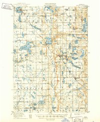
1911 Map of Barrett
USGS Topo · Published 1911About this map
The Pomme de Terre River carves a central path through this West Central Minnesota landscape, connecting a glacial chain of water bodies including Pomme de Terre Lake and Barrett Lake. At the time of this 1909-10 survey, the region was defined by a dense network of rural one-room schoolhouses, numbered systematically from School No 1 to School No 67, reflecting a peak era of agrarian settlement. The village of Barrett serves as a local hub, situated where the Minneapolis St Paul and Sault Ste Marie RR intersects the river valley. To the north and south, the Great Northern RR links larger settlements like Elbow Lake and Hoffman. This survey captures the county's early infrastructure before modern consolidation, preserving the locations of vanished community landmarks like the Union Church and the central Town Hall.
Find a feature on this map
73 named features on this map. Tap any name to fly to it.
Don’t see what you’re looking for? This feature index may not catch every label — zoom into the map to look around manually.
Map Details
Editions of this 1911 Barrett Map
2 editions found
Other maps of this area

1910 · Wendell
USGS Topo · 1:62,500

1910 · Chokio
USGS Topo · 1:62,500

1911 · Herman
USGS Topo · 1:62,500

1912 · Chokio
USGS Topo · 1:62,500

1912 · Morris
USGS Topo · 1:62,500

1913 · Ashby
USGS Topo · 1:62,500

1913 · Wendell
USGS Topo · 1:62,500

1953 · Milbank
USGS Topo · 1:250,000

1953 · Fargo
USGS Topo · 1:250,000

1953 · Brainerd
USGS Topo · 1:250,000