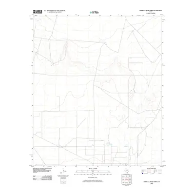
2010 Map of Barrilla Draw North
USGS Topo · Published 2010About this map
Barrilla Draw defines the drainage pattern across this arid landscape in Reeves County, carving a subtle path through the West Texas terrain. This 2010 USGS survey documents the rural infrastructure of the area during a period of transition in the Permian Basin's ranching and energy sectors. The map highlights a network of local transportation routes, most notably the intersection of Co Rd 112 and the larger Ranch Rd 2007, which provide essential access across the sparsely populated plains. The topography is marked by clear contour lines that reveal the gentle slopes and washes characteristic of this high-desert environment, offering a technical view of the land's natural drainage and elevation before further industrial or commercial development shifted the local footprint.
Find a feature on this map
3 named features on this map. Tap any name to fly to it.
Don’t see what you’re looking for? This feature index may not catch every label — zoom into the map to look around manually.
Map Details
Editions of this 2010 Barrilla Draw North Map
This is the sole edition of this map. No revisions or reprints were ever made.
Other maps of this area

1921 · Toyah
USGS Topo · 1:125,000

1931 · Barstow
USGS Topo · 1:125,000

1954 · Pecos
USGS Topo · 1:250,000

1955 · Saragosa
USGS Topo · 1:62,500

1957 · Pecos
USGS Topo · 1:250,000

1963 · Old X Ranch
USGS Topo · 1:24,000

1963 · Toyah Lake
USGS Topo · 1:24,000
1970 · Barstow 3 SW
USGS Topo · 1:24,000
1970 · Barstow 3 SE
USGS Topo · 1:24,000

1970 · Barstow 3 NE
USGS Topo · 1:24,000