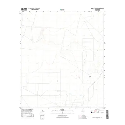
2016 Map of Barrilla Draw North
USGS Topo · Published 2016About this map
Barrilla Draw meanders through this portion of Reeves County, serving as the primary hydrological feature in an otherwise arid expanse. The landscape is defined by the subtle drainage patterns of the draw and the occasional network of rural transport routes that support the area's ranching interests. Modern infrastructure is represented by Ranch Rd 2007, which provides the most direct transit through the eastern section of the map, while a series of secondary thoroughfares including Co Rd 112, Co Rd 110, and K & D Rd crisscross the southern and central plains. These roads trace the property lines and access points essential for the remote operations of West Texas. This 2016 survey highlights the relationship between the natural topography of the draw and the human-made grid of ranch roads that navigate the basin.
Find a feature on this map
5 named features on this map. Tap any name to fly to it.
Don’t see what you’re looking for? This feature index may not catch every label — zoom into the map to look around manually.
Map Details
Editions of this 2016 Barrilla Draw North Map
This is the sole edition of this map. No revisions or reprints were ever made.
Other maps of this area

1921 · Toyah
USGS Topo · 1:125,000

1931 · Barstow
USGS Topo · 1:125,000

1954 · Pecos
USGS Topo · 1:250,000

1955 · Saragosa
USGS Topo · 1:62,500

1957 · Pecos
USGS Topo · 1:250,000

1963 · Old X Ranch
USGS Topo · 1:24,000

1963 · Toyah Lake
USGS Topo · 1:24,000
1970 · Barstow 3 SW
USGS Topo · 1:24,000
1970 · Barstow 3 SE
USGS Topo · 1:24,000

1970 · Barstow 3 NE
USGS Topo · 1:24,000