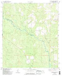
1978 Map of Barrineau Park
USGS Topo · Published 1993About this map
The Perdido River forms a winding natural boundary between Florida and Alabama in this late 1970s survey, anchoring a landscape defined by its waterways and small rural congregations. The settlement of Barrineau Park serves as a local hub, supported by the Barrineau Park Sch and several nearby country churches, including Lathram Chapel and St Elizabeths Ch. Traces of the region's earlier industrial infrastructure remain visible in the Old Railroad Grade that cuts across the southern portion of the quadrangle, while active resource extraction is noted by several Sandpits and a Claypit. Numerous tributaries like Alligator Creek and McDavid Creek drain the area, feeding into the Perdido. The map also records early residential development in places like Tenile and Sunny Hill, alongside family landmarks such as Pugh Chapel and the Little Flock Ch near the eastern margin.
Find a feature on this map
35 named features on this map. Tap any name to fly to it.
Don’t see what you’re looking for? This feature index may not catch every label — zoom into the map to look around manually.
Map Details
Editions of this 1978 Barrineau Park Map
3 editions found
Other maps of this area

1920 · Robertsdale
USGS Topo · 1:62,500

1921 · Muscogee
USGS Topo · 1:62,500

1941 · Muscogee
USGS Topo · 1:62,500

1941 · Robertsdale
USGS Topo · 1:62,500

1941 · Century
USGS Topo · 1:62,500

1942 · Dyas
USGS Topo · 1:62,500

1943 · Robertsdale
USGS Topo · 1:62,500

1943 · Muscogee
USGS Topo · 1:62,500

1943 · Century
USGS Topo · 1:62,500
1944 · Muscogee
USGS Topo · 1:25,000