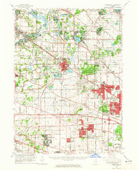
1961 Map of Barrington
USGS Topo · Published 1965About this map
Palatine, Barrington, and the emerging suburbs of the northwest Chicago corridor are captured during a period of rapid post-war expansion. The recently completed Northwest Tollway bisects the landscape, driving development in new communities like Hoffman Estates, Rolling Meadows, and Streamwood. Amidst this growth, the map preserves the older rural character of the region, marked by numerous small lakes such as Lake Zurich and Honey Lake, and substantial conservation areas including the Deer Grove Forest Preserve.
Find a feature on this map
114 named features on this map. Tap any name to fly to it.
Don’t see what you’re looking for? This feature index may not catch every label — zoom into the map to look around manually.
Map Details
Editions of this 1961 Barrington Map
This is the sole edition of this map. No revisions or reprints were ever made.
Other maps of this area

1891 · Riverside
USGS Topo · 1:62,500

1893 · Riverside
USGS Topo · 1:62,500

1900 · Riverside
USGS Topo · 1:62,500

1900 · Highwood
USGS Topo · 1:62,500

1901 · Riverside
USGS Topo · 1:62,500

1906 · Waukegan
USGS Topo · 1:62,500

1908 · Wheaton
USGS Topo · 1:62,500

1908 · Waukegan
USGS Topo · 1:62,500

1920 · Grays Lake
USGS Topo · 1:62,500

1923 · Grays Lake
USGS Topo · 1:62,500