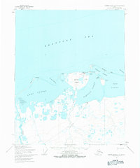
1955 Map of Barter Island A-5
USGS Topo · Published 1984About this map
Barter Island serves as the central focal point of this mid-1950s Arctic coastal survey, positioned where the Beaufort Sea meets a series of shallow lagoons. The settlement of Kaktovik is clearly established on the island's northern shore, accompanied by a nearby Landing Strip and a tower that signify the area's increasing strategic and logistical importance during this era. To the west, the former location of Elupak marks a historical point of human presence on the edge of Arey Lagoon. The landscape is defined by its dynamic water-to-land interface, featuring narrow barriers like Bernard Spit and deep indentations such as Bernard Harbor. Further inland, a Tractor Trail meanders through the marshy tundra toward the Okpilak River, illustrating the limited but vital overland transport routes used in this high-latitude environment before the proliferation of modern infrastructure.
Find a feature on this map
20 named features on this map. Tap any name to fly to it.
Don’t see what you’re looking for? This feature index may not catch every label — zoom into the map to look around manually.
Map Details
Editions of this 1955 Barter Island A-5 Map
3 editions found
Other maps of this area

1951 · Barter Island
USGS Topo · 1:250,000

1951 · Demarcation Point
USGS Topo · 1:250,000

1951 · Mt. Michelson
USGS Topo · 1:250,000

1955 · Flaxman Island
USGS Topo · 1:250,000

1955 · Demarcation Point
USGS Topo · 1:250,000

1955 · Flaxman Island A-1
USGS Topo · 1:63,360

1955 · Barter Island A-5
USGS Topo · 1:63,360

1955 · Barter Island A-4
USGS Topo · 1:63,360

1955 · Mount Michelson D-1
USGS Topo · 1:63,360

1955 · Demarcation Point D-5
USGS Topo · 1:63,360