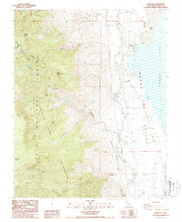
1987 Map of Bartlett
USGS Topo · Published 1987About this map
Owens Lake and the western edge of Owens Valley dominate this mid-1980s landscape, illustrating the heavy industrial and hydraulic modifications of the era. The settlement of Bartlett sits near the lakeshore, characterized by specialized operations such as Soda Evaporators and a series of levees designed to manage the receding water level. The presence of the Los Angeles Aqueduct and the Cottonwood Power Plant underscores the region's historical role in water and energy export.
Find a feature on this map
34 named features on this map. Tap any name to fly to it.
Don’t see what you’re looking for? This feature index may not catch every label — zoom into the map to look around manually.
Map Details
Editions of this 1987 Bartlett Map
3 editions found
Other maps of this area

1905 · Olancha
USGS Topo · 1:125,000

1907 · Olancha
USGS Topo · 1:125,000

1907 · Mt. Whitney
USGS Topo · 1:125,000

1908 · Ballarat
USGS Topo · 1:250,000

1913 · Ballarat
USGS Topo · 1:250,000

1919 · Mt. Whitney
USGS Topo · 1:125,000

1937 · Mt. Whitney
USGS Topo · 1:125,000

1948 · Death Valley
USGS Topo · 1:250,000

1948 · Fresno
USGS Topo · 1:250,000

1950 · New York Butte
USGS Topo · 1:62,500