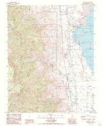
1987 Map of Bartlett
USGS Topo · Published 1991About this map
Owens Lake and the eastern edge of the Sierra Nevada dominate this landscape, illustrating a complex history of industrial mineral extraction and water management. Along the shoreline, Soda Evaporators indicate the commercial processing of the alkaline lake bed near Bartlett, while the Los Angeles Aqueduct and an Old Railroad Grade trace the transport corridors that reshaped the Owens Valley. The map captures the infrastructure of power and utility, including the Cottonwood Power Plant and a remote Radio Facility. To the west, the terrain rises sharply into the Inyo National Forest and Golden Trout Wilderness, where prominent summits like Timosea Peak and Muah Mountain overlook deep drainages such as Wormhole Canyon and Cottonwood Creek. This document serves as a detailed record of the physical and man-made environment before many of these industrial sites underwent further change.
Find a feature on this map
27 named features on this map. Tap any name to fly to it.
Don’t see what you’re looking for? This feature index may not catch every label — zoom into the map to look around manually.
Map Details
Editions of this 1987 Bartlett Map
3 editions found
Other maps of this area

1905 · Olancha
USGS Topo · 1:125,000

1907 · Olancha
USGS Topo · 1:125,000

1907 · Mt. Whitney
USGS Topo · 1:125,000

1908 · Ballarat
USGS Topo · 1:250,000

1913 · Ballarat
USGS Topo · 1:250,000

1919 · Mt. Whitney
USGS Topo · 1:125,000

1937 · Mt. Whitney
USGS Topo · 1:125,000

1948 · Death Valley
USGS Topo · 1:250,000

1948 · Fresno
USGS Topo · 1:250,000

1950 · New York Butte
USGS Topo · 1:62,500