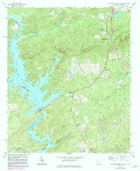
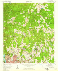
1965 Map of Bartletts Ferry Dam
USGS Topo · Published 1984About this map
Bartletts Ferry Dam dominates the lower reach of Lake Harding, a significant reservoir on the Chattahoochee River border between Georgia and Alabama. The landscape in the mid-1960s reveals a mix of hydroelectric infrastructure and rural community life, particularly in Mountain Hill with its namesake Mountain Hill Sch. The topography is defined by the ridges of Pine Mountain, where a Lookout Tower sits atop Williams Mtn, offering a vantage point over the wooded slopes and the winding Mulberry Creek. Local genealogy and social history are centered on numerous rural congregations, including Antioch Ch, Double Pine Ch, and Prospect Ch. Small, private water bodies like Lake Walter Richards and Lake Williams dot the interior, illustrating the area's development around water resources beyond the main river channel.
Find a feature on this map
33 named features on this map. Tap any name to fly to it.
Don’t see what you’re looking for? This feature index may not catch every label — zoom into the map to look around manually.
Map Details
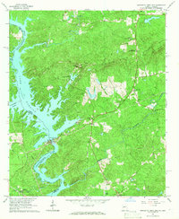
Editions of this 1965 Bartletts Ferry Dam Map
2 editions found
Other maps of this area

1907 · Talbotton
USGS Topo · 1:125,000

1907 · Opelika
USGS Topo · 1:125,000

1909 · Opelika
USGS Topo · 1:125,000

1950 · Fortson
USGS Topo · 1:24,000
1950 · Mulberry Grove
USGS Topo · 1:24,000

1950 · Ellerslie
USGS Topo · 1:62,500
1955 · Mulberry Grove
USGS Topo · 1:24,000
1955 · Fortson
USGS Topo · 1:24,000
1955 · Ellerslie
USGS Topo · 1:62,500

1955 · Phenix City
USGS Topo · 1:250,000