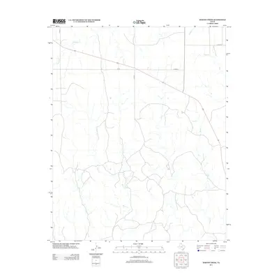
2012 Map of Barton Creek
USGS Topo · Published 2012About this map
Barton Cr winds through this section of the Texas Panhandle, defining a landscape shaped by intermittent watercourses and rural infrastructure. The map documents a sparsely populated region of Lipscomb County, where the primary landmarks are the local drainage systems and the grid of county roads that serve the ranching and agricultural community. The presence of Locust Grv in the northeast suggests a point of historical or industrial interest near the intersection of the county lines. Along with the central flow of Barton Cr, other significant waterways like Gibson Cr, Buffalo Cr, and Morgan Cr provide the geographical framework for this high plains territory. Transportation is anchored by Fm-281, which cuts diagonally across the northern half of the quadrangle, and Co Road Cc, linking the area to the wider county network.
Find a feature on this map
9 named features on this map. Tap any name to fly to it.
Don’t see what you’re looking for? This feature index may not catch every label — zoom into the map to look around manually.
Map Details
Editions of this 2012 Barton Creek Map
This is the sole edition of this map. No revisions or reprints were ever made.
Other maps of this area

1954 · Perryton
USGS Topo · 1:250,000

1954 · Amarillo
USGS Topo · 1:250,000

1958 · Perryton
USGS Topo · 1:250,000

1958 · Amarillo
USGS Topo · 1:250,000

1972 · Barton Corners
USGS Topo · 1:24,000

1972 · Horse Creek North
USGS Topo · 1:24,000

1972 · Canadian West
USGS Topo · 1:24,000

1972 · East Dry Creek
USGS Topo · 1:24,000
1972 · Lipscomb SW
USGS Topo · 1:24,000

1973 · Pickett Ranch Creek
USGS Topo · 1:24,000