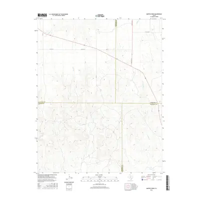
2016 Map of Barton Creek
USGS Topo · Published 2016About this map
Barton Cr winds through this high plains landscape at the intersection of four Texas Panhandle counties. This 2016 survey highlights the rugged drainage patterns where the headwaters of Gibson Cr, Buffalo Cr, and Morgan Cr carve through the terrain. The settlement of Locust Grove sits in the northeast, connected by a network of rural roads including Ranch Rd 281 and Ranch Rd 1265. The map is particularly significant for its depiction of the shared borders of Ochiltree, Lipscomb, Roberts, and Hemphill counties, showing how modern ranching infrastructure follows these administrative boundaries and natural watercourses in an area defined by its wide-open cattle country and sparse habitation.
Find a feature on this map
14 named features on this map. Tap any name to fly to it.
Don’t see what you’re looking for? This feature index may not catch every label — zoom into the map to look around manually.
Map Details
Editions of this 2016 Barton Creek Map
This is the sole edition of this map. No revisions or reprints were ever made.
Other maps of this area

1954 · Perryton
USGS Topo · 1:250,000

1954 · Amarillo
USGS Topo · 1:250,000

1958 · Perryton
USGS Topo · 1:250,000

1958 · Amarillo
USGS Topo · 1:250,000

1972 · Barton Corners
USGS Topo · 1:24,000

1972 · Horse Creek North
USGS Topo · 1:24,000

1972 · Canadian West
USGS Topo · 1:24,000

1972 · East Dry Creek
USGS Topo · 1:24,000
1972 · Lipscomb SW
USGS Topo · 1:24,000

1973 · Pickett Ranch Creek
USGS Topo · 1:24,000