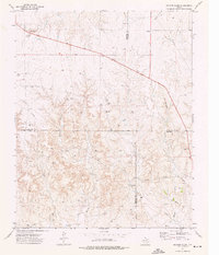
1973 Map of Barton Creek
USGS Topo · Published 1976About this map
The intersection of four Texas Panhandle counties—Ochiltree, Roberts, Lipscomb, and Hemphill—defines this 1970s landscape, where energy exploration and cattle ranching shape the terrain. The watershed of Barton Creek and its tributaries, including Gibson Creek and Morgan Creek, provides the primary drainage through a network of winding draws. The map documents the intensive development of natural resources during this era, marked by numerous Gas Wells and industrial infrastructure such as a Pumping Sta and various Drill Holes. While the land remains largely open, the presence of a Gravel Pit and several Gravel Pits alongside a primary road indicates the ongoing maintenance of the local transport network. This survey captures a specific moment in the energy history of the region, showing how Pipelines and access roads began to lace across the drainage of Buffalo Creek.
Find a feature on this map
14 named features on this map. Tap any name to fly to it.
Don’t see what you’re looking for? This feature index may not catch every label — zoom into the map to look around manually.
Map Details
Editions of this 1973 Barton Creek Map
This is the sole edition of this map. No revisions or reprints were ever made.
Other maps of this area

1954 · Perryton
USGS Topo · 1:250,000

1954 · Amarillo
USGS Topo · 1:250,000

1958 · Perryton
USGS Topo · 1:250,000

1958 · Amarillo
USGS Topo · 1:250,000

1972 · Barton Corners
USGS Topo · 1:24,000

1972 · Horse Creek North
USGS Topo · 1:24,000

1972 · Canadian West
USGS Topo · 1:24,000

1972 · East Dry Creek
USGS Topo · 1:24,000
1972 · Lipscomb SW
USGS Topo · 1:24,000

1973 · Pickett Ranch Creek
USGS Topo · 1:24,000