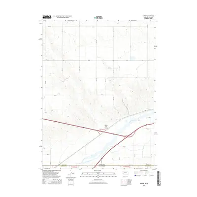
2014 Map of Barton
USGS Topo · Published 2014About this map
Barton sits at a critical junction of transport and irrigation in this high plains landscape. The South Platte River dominates the southern reaches of the map, flanked by the Western Canal and State Line Ditch, illustrating the managed water systems essential for agriculture in this arid region on the Nebraska-Colorado border. To the north, the terrain is marked by the winding course of Dry Cr and the Beasley Reservoir. This 2014 survey documents the modern layout of the land, where the historic path of Us-30 and the interstate system intersect near the local landmark of Walrath Draw. The grid of county roads, including Road 197 and Road 10, reveals the organized settlement patterns of Deuel and Sedgwick counties.
Find a feature on this map
28 named features on this map. Tap any name to fly to it.
Don’t see what you’re looking for? This feature index may not catch every label — zoom into the map to look around manually.
Map Details
Editions of this 2014 Barton Map
This is the sole edition of this map. No revisions or reprints were ever made.
Other maps of this area

1900 · Chappell
USGS Topo · 1:125,000

1953 · Julesburg
USGS Topo · 1:24,000

1954 · Sterling
USGS Topo · 1:250,000

1954 · Scottsbluff
USGS Topo · 1:250,000

1958 · Scottsbluff
USGS Topo · 1:250,000

1958 · Sterling
USGS Topo · 1:250,000

1961 · Barton
USGS Topo · 1:24,000

1961 · Big Springs
USGS Topo · 1:24,000

1961 · Chappell SE
USGS Topo · 1:24,000
1962 · Venango NE
USGS Topo · 1:24,000