
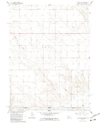
1961 Map of Chappell SE
USGS Topo · Published 1963About this map
High plains ranching and agricultural patterns define this corner of the Nebraska-Colorado border as it appeared in the early 1960s. The landscape is etched by a series of north-south drainage systems, including Walrath Draw, O'Neil Draw, and Hartley Draw, which navigate the rolling terrain. Human activity is centered around remote rural institutions like Swan Center Sch in the north and School No 41 to the south. The mapping of the State Line between Deuel County, Nebraska, and Sedgwick County, Colorado, illustrates the surveyed grid of the American West, where property and political lines often ignore the subtle contours of the earth. Water management is evident near the southern boundary, where the Peterson Ditch provides essential irrigation for the high-altitude prairie environment.
Find a feature on this map
9 named features on this map. Tap any name to fly to it.
Don’t see what you’re looking for? This feature index may not catch every label — zoom into the map to look around manually.
Map Details
Editions of this 1961 Chappell SE Map
2 editions found
Other maps of this area

1900 · Chappell
USGS Topo · 1:125,000

1953 · Ovid
USGS Topo · 1:24,000

1953 · Julesburg
USGS Topo · 1:24,000

1954 · Sterling
USGS Topo · 1:250,000

1954 · Scottsbluff
USGS Topo · 1:250,000

1958 · Scottsbluff
USGS Topo · 1:250,000

1958 · Sterling
USGS Topo · 1:250,000

1961 · Chappell
USGS Topo · 1:24,000

1961 · Barton
USGS Topo · 1:24,000
1962 · Venango NW
USGS Topo · 1:24,000