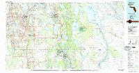
1978 Map of Bartow
USGS Topo · Published 1980About this map
Peace River and the Seaboard Coast Line define the corridor of development in central Florida during the late 1970s. The landscape is a study in industrial transformation, dominated by extensive strip mining operations near Mulberry and Kingsford, where the earth has been reshaped for phosphate extraction. This intensive land use contrasts sharply with the vast natural wetlands and water bodies to the east, including the massive Lake Weohyakapka and the serpentine Kissimmee River.
Find a feature on this map
132 named features on this map. Tap any name to fly to it.
Don’t see what you’re looking for? This feature index may not catch every label — zoom into the map to look around manually.
Map Details
Editions of this 1978 Bartow Map
2 editions found
Other maps of this area

1944 · Plant City
USGS Topo · 1:31,680

1944 · Lakeland
USGS Topo · 1:31,680

1944 · Auburndale
USGS Topo · 1:31,680

1949 · Mulberry
USGS Topo · 1:24,000

1949 · Bartow
USGS Topo · 1:24,000

1949 · Bradley Junction
USGS Topo · 1:24,000

1950 · Mulberry
USGS Topo · 1:24,000

1950 · Bartow
USGS Topo · 1:24,000

1950 · Bradley Junction
USGS Topo · 1:24,000

1952 · Homeland
USGS Topo · 1:24,000