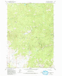
1963 Map of Basin Butte
USGS Topo · Published 1993About this map
Basin Butte Lookout stands at 8,954 feet, overseeing a landscape of the Challis National Forest during the early 1960s. This drainage basin is defined by a dense network of watercourses, including the East Fork Valley Creek and Sunday Creek, which flow through the high-elevation terrain. Evidence of the region's extractive history is visible in the numerous mining sites and prospects distributed throughout the area. Specifically, the Hay Creek Mine and multiple unnamed prospects near Sawmill Creek indicate a period of active mineral exploration. The isolation of the area is underscored by the presence of Cow Camp and a system of 4WD tracks that provide the only access to landmarks like Potato Mountain and the secluded Valley Creek Lake.
Find a feature on this map
27 named features on this map. Tap any name to fly to it.
Don’t see what you’re looking for? This feature index may not catch every label — zoom into the map to look around manually.
Map Details
Editions of this 1963 Basin Butte Map
3 editions found
Other maps of this area

1891 · Bear Valley
USGS Topo · 1:125,000

1893 · Bear Valley
USGS Topo · 1:125,000

1919 · Custer
USGS Topo · 1:125,000

1922 · Custer
USGS Topo · 1:125,000

1957 · Challis
USGS Topo · 1:250,000

1960 · Challis
USGS Topo · 1:250,000

1963 · Challis
USGS Topo · 1:250,000

1963 · Stanley
USGS Topo · 1:24,000

1963 · Basin Butte
USGS Topo · 1:24,000

1963 · Casino Lakes
USGS Topo · 1:24,000