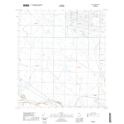
2018 Map of Basinger
USGS Topo · Published 2018About this map
Basinger and Cornwell serve as the primary hubs in this central Florida landscape, situated along the border of Highlands and Okeechobee counties. The winding Kissimmee River cuts across the southwestern corner, accompanied by a portion of the Florida National Scenic Trail. The terrain is defined by a series of wetlands and water features typical of the region, including Ash Slough, Chandler Slough, and the expansive Wolf Sawgrass Pond. To the west, Turkey Hammock provides a named landmark amidst the network of drainage ways like Gore Br. Large landholdings such as Chandler Ranch and Sherman Ranch dominate much of the acreage, while a dense grid of numbered roads, like NW 276th St, pushes into the northern sections of the map. For genealogists, the Basinger Cem provides a specific point of interest in the town of Basinger.
Find a feature on this map
63 named features on this map. Tap any name to fly to it.
Don’t see what you’re looking for? This feature index may not catch every label — zoom into the map to look around manually.
Map Details
Editions of this 2018 Basinger Map
This is the sole edition of this map. No revisions or reprints were ever made.
Other maps of this area

1952 · Fort Kissimmee
USGS Topo · 1:24,000

1953 · Taylor Creek NW
USGS Topo · 1:24,000

1953 · Basinger
USGS Topo · 1:24,000

1953 · Fort Basinger
USGS Topo · 1:24,000

1953 · Fort Drum SW
USGS Topo · 1:24,000

1953 · Basinger SW
USGS Topo · 1:24,000

1953 · Basinger NW
USGS Topo · 1:24,000

1953 · Taylor Creek SW
USGS Topo · 1:24,000

1953 · Fort Kissimmee SE
USGS Topo · 1:24,000

1956 · Fort Pierce
USGS Topo · 1:250,000