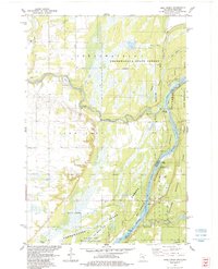
1983 Map of Bass Creek
USGS Topo · Published 1984About this map
The confluence of the Snake River and the St Croix River defines the heart of this landscape, marking the border between Minnesota and Wisconsin. Broad marshlands and riverine ecosystems dominate the eastern half of the map, protected within the Chengwatana State Forest and the St Croix National Scenic Riverway. The terrain transitions from the high, flat plains of Pine City and Rock Creek in the west down toward the river valley, where local access points like Soderbeck Landing and Snake River Landing facilitate movement along the waterways.
Find a feature on this map
26 named features on this map. Tap any name to fly to it.
Don’t see what you’re looking for? This feature index may not catch every label — zoom into the map to look around manually.
Map Details
Editions of this 1983 Bass Creek Map
2 editions found
Other maps of this area

1950 · Rush City
USGS Topo · 1:48,000

1950 · Grantsburg
USGS Topo · 1:48,000

1951 · Milltown
USGS Topo · 1:48,000

1953 · Stillwater
USGS Topo · 1:250,000

1955 · Rush City
USGS Topo · 1:62,500

1955 · Milltown
USGS Topo · 1:62,500

1955 · Stillwater
USGS Topo · 1:250,000

1958 · Stillwater
USGS Topo · 1:250,000

1961 · Pine City
USGS Topo · 1:62,500

1962 · Grantsburg
USGS Topo · 1:62,500