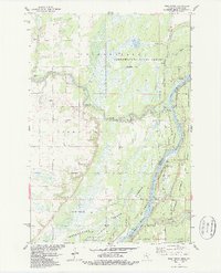
1983 Map of Bass Creek
USGS Topo · Published 1987About this map
The St Croix River defines the border between Minnesota and Wisconsin in this 1980s survey, anchoring a landscape dedicated to conservation and recreation. To the west, the Chengwatana State Forest and the Chengwatana State Wildlife Management Area preserve a mosaic of wetlands and timberland, including Long Meadows Lake and the winding course of the Snake River. This river system served as a historic transportation corridor, reflected here by riverfront access points like Snake River Landing and Soderbeck Landing. On the Wisconsin side, the Governor Knowles State Forest provides a buffer along the St Croix National Scenic Riverway. The map captures the area's transition into a modern recreational hub, featuring a network of sites such as the Sandrock Cliff Campground and several Snowmobile Trails that crisscross the forested terrain.
Find a feature on this map
28 named features on this map. Tap any name to fly to it.
Don’t see what you’re looking for? This feature index may not catch every label — zoom into the map to look around manually.
Map Details
Editions of this 1983 Bass Creek Map
2 editions found
Other maps of this area

1950 · Rush City
USGS Topo · 1:48,000

1950 · Grantsburg
USGS Topo · 1:48,000

1951 · Milltown
USGS Topo · 1:48,000

1953 · Stillwater
USGS Topo · 1:250,000

1955 · Rush City
USGS Topo · 1:62,500

1955 · Milltown
USGS Topo · 1:62,500

1955 · Stillwater
USGS Topo · 1:250,000

1958 · Stillwater
USGS Topo · 1:250,000

1961 · Pine City
USGS Topo · 1:62,500

1962 · Grantsburg
USGS Topo · 1:62,500