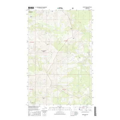
2017 Map of Bassoo Peak
USGS Topo · Published 2017About this map
The high ridges of Lolo National Forest dominate this 2017 survey at the border of Sanders and Flathead counties. The terrain is defined by a series of prominent summits, including Snowstorm Mtn, Bassoo Peak, and Pashua Peak, which form a high drainage divide for the surrounding watershed. Water management in this steep environment is evidenced by the presence of the Alder Cr Ditch in the southeast corner, redirecting flows through the complex topography of the Salish Mountains.
Find a feature on this map
21 named features on this map. Tap any name to fly to it.
Don’t see what you’re looking for? This feature index may not catch every label — zoom into the map to look around manually.
Map Details
Editions of this 2017 Bassoo Peak Map
This is the sole edition of this map. No revisions or reprints were ever made.
Other maps of this area

1956 · Wallace
USGS Topo · 1:250,000

1960 · Wallace
USGS Topo · 1:250,000

1964 · Mill Pocket Creek
USGS Topo · 1:24,000

1964 · Coney Peak
USGS Topo · 1:24,000

1964 · Hubbart Reservoir
USGS Topo · 1:24,000
1964 · Cook Mountain
USGS Topo · 1:24,000
1964 · Shroder Creek
USGS Topo · 1:24,000

1964 · Murr Peak
USGS Topo · 1:24,000

1964 · Lonepine
USGS Topo · 1:24,000
1964 · Bassoo Peak
USGS Topo · 1:24,000