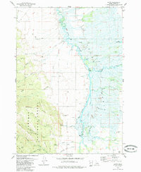
1979 Map of Bates
USGS Topo · Published 1985About this map
The Teton River meanders through the heart of the Teton Basin in this late 1970s survey, creating a complex network of wetlands and side channels including Elliott Slough and Foster Slough. The landscape transitions from the marshy valley floor to the prominent slopes of the Big Hole Mts and the protected lands of the Targhee National Forest. Smaller settlements such as Bates and Cedron anchor the agricultural and ranching area, each served by their respective burial grounds, the Bates Cem and Cedron Cem.
Find a feature on this map
51 named features on this map. Tap any name to fly to it.
Don’t see what you’re looking for? This feature index may not catch every label — zoom into the map to look around manually.
Map Details
Editions of this 1979 Bates Map
2 editions found
Other maps of this area

1943 · Driggs
USGS Topo · 1:62,500

1943 · Garns Mtn
USGS Topo · 1:62,500

1946 · Driggs
USGS Topo · 1:62,500

1946 · Garns Mtn
USGS Topo · 1:62,500

1955 · Driggs
USGS Topo · 1:250,000

1958 · Driggs
USGS Topo · 1:250,000

1962 · Driggs
USGS Topo · 1:250,000

1965 · Packsaddle Lake
USGS Topo · 1:24,000

1965 · Clawson
USGS Topo · 1:24,000
1965 · Tetonia
USGS Topo · 1:24,000