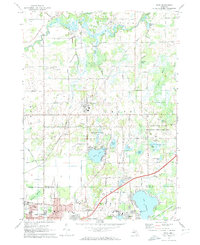
1972 Map of Bath
USGS Topo · Published 1974About this map
The Looking Glass River winds through the northern reaches of this Clinton County landscape, defining a terrain shaped by post-glacial hydrology and mid-century suburban expansion. The settlement of Bath is centered along Sleight Road, while the southern edge of the map shows the burgeoning residential footprint of East Lansing and Haslett. This era captures a distinct mix of recreational and institutional land use, from the Rose Lake State Wildlife Research Area and its associated Rose Lake Stoll Church to the leisure-focused southern lakes. Notable community fixtures like Pleasant Hill Cemetery and the Townhall sit alongside modern developments such as the Walnut Hills Country Club and an Amusement Park on the shores of Lake Lansing. The presence of the Grand Trunk Western Railroad near Haslett illustrates the enduring importance of this rail corridor even as automotive infrastructure like State Road grew to dominate the region.
Find a feature on this map
64 named features on this map. Tap any name to fly to it.
Don’t see what you’re looking for? This feature index may not catch every label — zoom into the map to look around manually.
Map Details
Editions of this 1972 Bath Map
2 editions found
Other maps of this area

1909 · Mason
USGS Topo · 1:62,500

1910 · Lansing
USGS Topo · 1:62,500

1911 · Mason
USGS Topo · 1:62,500

1912 · Lansing
USGS Topo · 1:62,500

1927 · De Witt
USGS Topo · 1:62,500

1928 · Laingsburg
USGS Topo · 1:62,500

1944 · Laingsburg
USGS Topo · 1:62,500

1958 · Grand Rapids
USGS Topo · 1:250,000

1961 · Grand Rapids
USGS Topo · 1:250,000

1962 · Grand Rapids
USGS Topo · 1:250,000
Featured Places
- East Lansing, MI
- Meridian Charter Township, MI
- DeWitt Charter Township, MI
- Olive Township, MI
- Bath Charter Township, MI