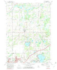
1972 Map of Bath
USGS Topo · Published 1982About this map
The Looking Glass River meanders through the northern reaches of this Clinton County landscape, defining a terrain shaped by glacial wetlands and small lakes. In the early 1970s, the village of Bath serves as a central hub, surrounded by family-anchored landmarks like Pleasant Hill Cem and Townhall. The southern portion of the sheet captures the suburban expansion of East Lansing and Haslett, where leisure and research dominate the land use. From the expansive Rose Lake State Wildlife Research Area with its numerous lookout towers to the Amusement Park on the shores of Lake Lansing, the map illustrates a transition from rural agricultural plots to recreational and scientific spaces. Notable mid-century infrastructure is visible in the Grand Trunk Western railroad corridor and local aviation sites such as Davis Airport and University Air Park.
Find a feature on this map
67 named features on this map. Tap any name to fly to it.
Don’t see what you’re looking for? This feature index may not catch every label — zoom into the map to look around manually.
Map Details
Editions of this 1972 Bath Map
2 editions found
Other maps of this area

1909 · Mason
USGS Topo · 1:62,500

1910 · Lansing
USGS Topo · 1:62,500

1911 · Mason
USGS Topo · 1:62,500

1912 · Lansing
USGS Topo · 1:62,500

1927 · De Witt
USGS Topo · 1:62,500

1928 · Laingsburg
USGS Topo · 1:62,500

1944 · Laingsburg
USGS Topo · 1:62,500

1958 · Grand Rapids
USGS Topo · 1:250,000

1961 · Grand Rapids
USGS Topo · 1:250,000

1962 · Grand Rapids
USGS Topo · 1:250,000
Featured Places
- East Lansing, MI
- Meridian Charter Township, MI
- DeWitt Charter Township, MI
- Olive Township, MI
- Bath Charter Township, MI