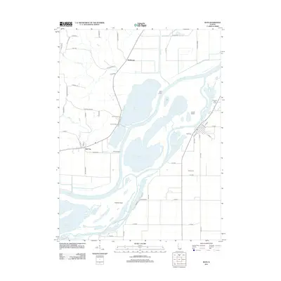
2012 Map of Bath
USGS Topo · Published 2012About this map
The Illinois River dominates this landscape, creating a complex network of backwater lakes, sloughs, and massive river islands like Grand Island and Snicarte Island. The village of Bath is situated on the eastern bank, its grid of streets including S Locust St and E Main St leading toward the river's edge. This 2012 survey illustrates how the floodplains are managed, with several landing points like West Point Landing and Holmes Landing providing access to the water, while settlements like Bluff City and Marbletown occupy the higher ground to the west.
Find a feature on this map
66 named features on this map. Tap any name to fly to it.
Don’t see what you’re looking for? This feature index may not catch every label — zoom into the map to look around manually.
Map Details
Editions of this 2012 Bath Map
This is the sole edition of this map. No revisions or reprints were ever made.
Other maps of this area

1918 · Vermont
USGS Topo · 1:62,500

1921 · Vermont
USGS Topo · 1:62,500

1925 · Havana
USGS Topo · 1:62,500

1926 · Beardstown
USGS Topo · 1:62,500

1930 · Chandlerville
USGS Topo · 1:62,500

1932 · Chandlerville
USGS Topo · 1:62,500

1944 · Beardstown
USGS Topo · 1:62,500

1947 · Havana
USGS Topo · 1:24,000

1948 · Duncan Mills
USGS Topo · 1:24,000
1948 · Havana
USGS Topo · 1:24,000