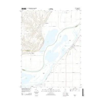
2015 Map of Bath
USGS Topo · Published 2015About this map
The Illinois River dominates this landscape at the intersection of Mason, Schuyler, and Fulton counties, carving a complex network of backwaters and islands. The village of Bath sits on the eastern bank, its grid of streets such as S Locust St and E Main St positioned near the edge of Bath Lake. To the west, the river creates large landforms like Grand Island and Snicarte Island, surrounded by a series of shallow basins including Patterson Bay, Jack Lake, and Stickey Lake. This watery environment has historically defined local life, from the small clusters at Bluff City and Snicarte to the rural outposts like Marbletown. The terrain transitions from the broad alluvial valley into the higher bluffs to the northwest, where Kerton Cr and Wilson Cr drain toward the river. Local heritage is grounded in sites like Bath Cem, while the modern road network, including Patterson Bay Rd, traces the edges of these persistent wetlands.
Find a feature on this map
64 named features on this map. Tap any name to fly to it.
Don’t see what you’re looking for? This feature index may not catch every label — zoom into the map to look around manually.
Map Details
Editions of this 2015 Bath Map
This is the sole edition of this map. No revisions or reprints were ever made.
Other maps of this area

1918 · Vermont
USGS Topo · 1:62,500

1921 · Vermont
USGS Topo · 1:62,500

1925 · Havana
USGS Topo · 1:62,500

1926 · Beardstown
USGS Topo · 1:62,500

1930 · Chandlerville
USGS Topo · 1:62,500

1932 · Chandlerville
USGS Topo · 1:62,500

1944 · Beardstown
USGS Topo · 1:62,500

1947 · Havana
USGS Topo · 1:24,000

1948 · Duncan Mills
USGS Topo · 1:24,000
1948 · Havana
USGS Topo · 1:24,000