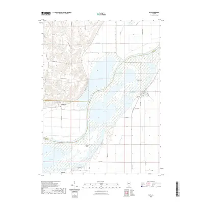
2021 Map of Bath
USGS Topo · Published 2021About this map
The Illinois River dominates this landscape, carving a wide alluvial valley that defines the borders of Mason, Fulton, and Schuyler counties. In the village of Bath, a structured grid of streets including E Main St and S Locust St sits adjacent to the East Branch Illinois River, while the Bath Cem marks the eastern edge of the settlement. Across the river to the west, the terrain rises sharply into the bluffs where Bluff City and its associated Bluff City Cem overlook the bottomlands.
Find a feature on this map
64 named features on this map. Tap any name to fly to it.
Don’t see what you’re looking for? This feature index may not catch every label — zoom into the map to look around manually.
Map Details
Editions of this 2021 Bath Map
This is the sole edition of this map. No revisions or reprints were ever made.
Other maps of this area

1918 · Vermont
USGS Topo · 1:62,500

1921 · Vermont
USGS Topo · 1:62,500

1925 · Havana
USGS Topo · 1:62,500

1926 · Beardstown
USGS Topo · 1:62,500

1930 · Chandlerville
USGS Topo · 1:62,500

1932 · Chandlerville
USGS Topo · 1:62,500

1944 · Beardstown
USGS Topo · 1:62,500

1947 · Havana
USGS Topo · 1:24,000

1948 · Duncan Mills
USGS Topo · 1:24,000
1948 · Havana
USGS Topo · 1:24,000