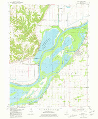
1981 Map of Bath
USGS Topo · Published 1981About this map
The Illinois River dominates this 1981 survey of Mason and Fulton Counties, creating a complex network of backwaters and wetlands protected within the Anderson Lake State Conservation Area. The landscape is a study in river-adjacent livelihoods, featuring the village of Bath and small riverfront outposts like Holmes Landing. The intricate hydrology is defined by the Snicarte Slough, Patterson Bay, and numerous lakes such as Swan Lake and Moscow Lake, which are separated by a system of levees. On the eastern bank, an old railroad grade runs parallel to the river near Bluff City, marking a former transportation corridor through the floodplains. To the north, Marbletown sits near the mouth of Otter Creek, where the wetlands transition into the agricultural fields of the Illinois river valley.
Find a feature on this map
41 named features on this map. Tap any name to fly to it.
Don’t see what you’re looking for? This feature index may not catch every label — zoom into the map to look around manually.
Map Details
Editions of this 1981 Bath Map
This is the sole edition of this map. No revisions or reprints were ever made.
Other maps of this area

1918 · Vermont
USGS Topo · 1:62,500

1921 · Vermont
USGS Topo · 1:62,500

1925 · Havana
USGS Topo · 1:62,500

1926 · Beardstown
USGS Topo · 1:62,500

1930 · Chandlerville
USGS Topo · 1:62,500

1932 · Chandlerville
USGS Topo · 1:62,500

1944 · Beardstown
USGS Topo · 1:62,500

1947 · Havana
USGS Topo · 1:24,000

1948 · Duncan Mills
USGS Topo · 1:24,000
1948 · Havana
USGS Topo · 1:24,000