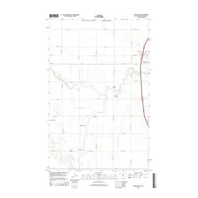
2014 Map of Bathgate NE
USGS Topo · Published 2014About this map
Pembina sits at the northeastern edge of this Red River Valley landscape, just south of the international border. The territory is defined by the winding course of the Pembina River and the Tongue River, which flow through a heavily engineered agricultural plain. A complex network of drainage systems, including County Ditch Number 42 and County Ditch Number 11, reflects the intensive water management required for farming in this low-lying region. Local crossings such as Hancock Bridge and Trudell Bridge provide vital links across the meandering waterways and coulees. The presence of Pembina Cem north of the settlement serves as a quiet landmark for genealogists tracing the early families of North Dakota's oldest established community. The map also captures the Tongue River Cutoff and several named coulees, such as Icelandic Coulee and Louden Coulee, which disrupt the otherwise orderly grid of section roads.
Find a feature on this map
35 named features on this map. Tap any name to fly to it.
Don’t see what you’re looking for? This feature index may not catch every label — zoom into the map to look around manually.
Map Details
Editions of this 2014 Bathgate NE Map
This is the sole edition of this map. No revisions or reprints were ever made.
Other maps of this area

1939 · Pembina
USGS Topo · 1:62,500

1941 · Bathgate
USGS Topo · 1:62,500

1941 · Pembina
USGS Topo · 1:62,500

1952 · Thief River Falls
USGS Topo · 1:250,000

1956 · Thief River Falls
USGS Topo · 1:250,000

1957 · Thief River Falls
USGS Topo · 1:250,000

1967 · Thief River Falls
USGS Topo · 1:250,000
1970 · Bathgate SE
USGS Topo · 1:24,000
1970 · Bathgate NE
USGS Topo · 1:24,000
1971 · Bathgate
USGS Topo · 1:24,000