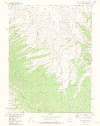
1979 Map of Battle Mountain
USGS Topo · Published 1979About this map
Battle Mountain dominates the center of this high-elevation landscape within the Arapaho National Forest, where the complex drainage systems of the Williams Fork and Battle Creek intersect. The terrain is marked by significant hydraulic features like the Big Lake Ditch, reflecting the importance of water management in this part of the Arapaho Mountains. A notable Landing Strip sits along the northern reaches near Williams Fork, providing a rare point of aviation access in an otherwise remote area accessed primarily by a network of Jeep Trails and pack trails. This survey reveals a landscape largely defined by its natural topography and resource extraction, indicated by Gravel Pits and named summits such as Williams Peak and Jessmer.
Find a feature on this map
28 named features on this map. Tap any name to fly to it.
Don’t see what you’re looking for? This feature index may not catch every label — zoom into the map to look around manually.
Map Details
Editions of this 1979 Battle Mountain Map
4 editions found
Other maps of this area

1933 · Mt. Powell
USGS Topo · 1:48,000

1933 · Ute Peak
USGS Topo · 1:62,500

1937 · Ute Peak
USGS Topo · 1:62,500

1940 · Mount Powell
USGS Topo · 1:62,500

1954 · Craig
USGS Topo · 1:250,000

1956 · Kremmling
USGS Topo · 1:62,500

1957 · Craig
USGS Topo · 1:250,000

1957 · Hot Sulphur Springs
USGS Topo · 1:62,500

1957 · Leadville
USGS Topo · 1:250,000

1958 · Craig
USGS Topo · 1:250,000