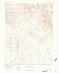
1962 Map of Battleship Rock
USGS Topo · Published 1964About this map
Black Ridge dominates this high-altitude landscape on the western edge of the Colorado National Monument. In the early 1960s, this area of Mesa County remained largely defined by traditional land use and difficult terrain, evidenced by the presence of the Parrish Homestead and Leslie Homestead. These sites represent the persistent ranching and homesteading history of the high desert plateau, situated amidst a complex network of drainages like Devils Canyon and Rattlesnake Canyon.
Find a feature on this map
24 named features on this map. Tap any name to fly to it.
Don’t see what you’re looking for? This feature index may not catch every label — zoom into the map to look around manually.
Map Details
Editions of this 1962 Battleship Rock Map
4 editions found
Other maps of this area

1934 · Colorado National Monument
USGS Topo · 1:24,000

1956 · Moab
USGS Topo · 1:250,000

1956 · Grand Junction
USGS Topo · 1:250,000

1959 · Grand Junction
USGS Topo · 1:250,000

1959 · Moab
USGS Topo · 1:250,000

1960 · Moab
USGS Topo · 1:250,000

1960 · Grand Junction
USGS Topo · 1:250,000

1962 · Moab
USGS Topo · 1:250,000

1962 · Grand Junction
USGS Topo · 1:250,000

1962 · Fruita
USGS Topo · 1:24,000