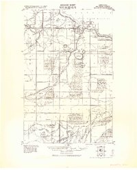
1921 Map of Baudette
USGS Topo · Published 1943About this map
The International Boundary between the United States and Canada anchors this northern Minnesota landscape, where the Rainy River flows past the adjacent settlements of Baudette and Spooner. This survey reflects a period of intensive drainage and land reclamation, documented through an intricate network of civil engineering projects including Judicial Ditch No 26, Judicial Ditch No 27, and Judicial Ditch No 28. These features, alongside notes on timber and swamp limits from surveys of Ceded Chippewa Lands, reveal the systematic effort to convert the northern wilderness into manageable tracts.
Find a feature on this map
41 named features on this map. Tap any name to fly to it.
Don’t see what you’re looking for? This feature index may not catch every label — zoom into the map to look around manually.
Map Details
Editions of this 1921 Baudette Map
2 editions found
Other maps of this area

1918 · Williams
USGS Topo · 1:62,500

1919 · Peppermint Creek
USGS Topo · 1:62,500

1919 · G
USGS Topo · 1:62,500

1919 · Canada
USGS Topo · 1:62,500

1919 · Knutson
USGS Topo · 1:62,500

1921 · Baudette
USGS Topo · 1:62,500

1943 · Peppermint Creek
USGS Topo · 1:62,500

1954 · Roseau
USGS Topo · 1:250,000

1957 · Roseau
USGS Topo · 1:250,000

1958 · Roseau
USGS Topo · 1:250,000