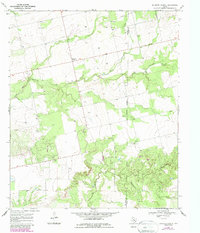
1969 Map of Baumann School
USGS Topo · Published 1987About this map
Baumann School stands as a central landmark in this rural West Texas landscape, positioned near the boundary between Mitchell and Nolan counties. The 1960s terrain is defined by a complex network of seasonal drainage, with the South Fork Champion Creek winding through the center, joined by Hanks Hollow. Further south, the map details the courses of Cottonwood Creek, Big Silver Creek, and Red Bull Creek, illustrating the natural watershed patterns typical of this semi-arid region.
Find a feature on this map
15 named features on this map. Tap any name to fly to it.
Don’t see what you’re looking for? This feature index may not catch every label — zoom into the map to look around manually.
Map Details
Editions of this 1969 Baumann School Map
2 editions found
Other maps of this area

1950 · Colorado City SE
USGS Topo · 1:24,000

1952 · Colorado City
USGS Topo · 1:24,000

1954 · Big Spring
USGS Topo · 1:250,000

1958 · Big Spring
USGS Topo · 1:250,000

1959 · Pecan Crossing
USGS Topo · 1:24,000

1959 · Dam Draw
USGS Topo · 1:24,000

1969 · Baumann School
USGS Topo · 1:24,000

1969 · Bench Mountain
USGS Topo · 1:24,000

1969 · Loraine
USGS Topo · 1:24,000
1969 · Dew Drop Creek
USGS Topo · 1:24,000