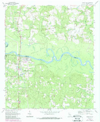
1970 Map of Baxley NE
USGS Topo · Published 1988About this map
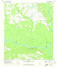
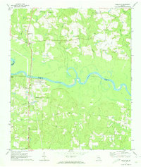
The winding Altamaha River serves as the dividing line between Toombs and Appling counties, anchoring a landscape defined by riverside settlements and rural community hubs. In the northwest, the riverfront hamlet of English Eddy is supported by the English Eddy Church and its namesake cemetery, while the nearby Smith Cash landmark points to early local commerce. Industrial development is evident near the powerplant and Substa, contrasting with the numerous family and community landmarks like Old Campground Cemetery and Griner Cemetery that populate the surrounding woodlands.
Find a feature on this map
39 named features on this map. Tap any name to fly to it.
Don’t see what you’re looking for? This feature index may not catch every label — zoom into the map to look around manually.
Map Details
Editions of this 1970 Baxley NE Map
2 editions found
Other maps of this area

1953 · Waycross
USGS Topo · 1:250,000

1957 · Macon
USGS Topo · 1:250,000

1958 · Macon
USGS Topo · 1:250,000

1958 · Waycross
USGS Topo · 1:250,000

1964 · Macon
USGS Topo · 1:250,000
1970 · Johnson Corner
USGS Topo · 1:24,000
1970 · Alston
USGS Topo · 1:24,000
1970 · Reidsville West
USGS Topo · 1:24,000
1970 · Altamaha
USGS Topo · 1:24,000
1970 · Baxley NE
USGS Topo · 1:24,000