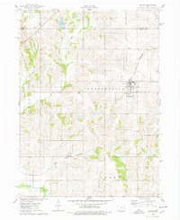
1975 Map of Baxter
USGS Topo · Published 1978About this map
Baxter serves as the central hub for this agricultural landscape during the mid-1970s, situated at the junction where the Chicago and North Western railroad cuts diagonally through the prairie. The town is surrounded by a network of rural townships including Independence, Eden, and Sherman, with the terrain marked by several small family and community burial grounds such as Restland Cem and Bethel Cem.
Find a feature on this map
25 named features on this map. Tap any name to fly to it.
Don’t see what you’re looking for? This feature index may not catch every label — zoom into the map to look around manually.
Map Details
Editions of this 1975 Baxter Map
This is the sole edition of this map. No revisions or reprints were ever made.
Other maps of this area

1930 · Mitchellville
USGS Topo · 1:62,500

1954 · Des Moines
USGS Topo · 1:250,000

1956 · Des Moines
USGS Topo · 1:250,000

1957 · Des Moines
USGS Topo · 1:250,000

1965 · Newton
USGS Topo · 1:24,000

1965 · Colfax
USGS Topo · 1:24,000

1969 · Des Moines
USGS Topo · 1:250,000
1972 · Mitchellville
USGS Topo · 1:24,000

1975 · Mingo
USGS Topo · 1:24,000

1975 · Rhodes
USGS Topo · 1:24,000