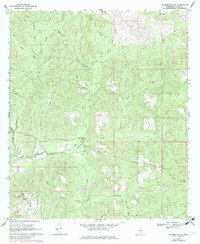
1969 Map of Baxterville NE
USGS Topo · Published 1982About this map
The rural landscape of Lamar County is defined by a dense network of watercourses and early community landmarks as they appeared in 1969. Local life centers on established congregations such as Greenville Ch, Bay Creek Ch, and Caney Ch, with the Bay Creek Cem serving as a significant genealogical record for the area. The terrain is characterized by numerous small branches and brakes, including Berry Brake Creek and Gum Reed Brake Creek, which feed into larger systems like Little Black Creek.
Find a feature on this map
38 named features on this map. Tap any name to fly to it.
Don’t see what you’re looking for? This feature index may not catch every label — zoom into the map to look around manually.
Map Details
Editions of this 1969 Baxterville NE Map
2 editions found
Other maps of this area

1953 · Hattiesburg
USGS Topo · 1:250,000

1958 · Hattiesburg
USGS Topo · 1:250,000

1964 · Purvis
USGS Topo · 1:24,000

1964 · Lumberton
USGS Topo · 1:24,000

1965 · Hattiesburg SW
USGS Topo · 1:24,000

1969 · Baxterville SW
USGS Topo · 1:24,000
1969 · Baxterville
USGS Topo · 1:24,000

1969 · Baxterville NE
USGS Topo · 1:24,000

1969 · Pinebur
USGS Topo · 1:24,000

1974 · Oloh
USGS Topo · 1:24,000