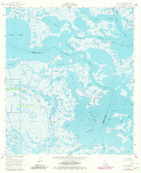
1953 Map of Bay Dosgris
USGS Topo · Published 1980About this map
Grand Bayou and Old Grand Bayou wind through a complex network of marshlands and open water at the border of Jefferson and Lafourche Parishes. The coastal landscape is defined by the industrial footprint of the Hackberry Oil Field, where numerous Oil Wells, platforms, and a Submerged Pipeline indicate the mid-century expansion of petroleum extraction in the Louisiana wetlands. Movement through these tidal waters is facilitated by the Barataria Waterway and Bayou St Denis, which serve as vital arteries connecting Little Lake and Bayou Dosgris to the larger Barataria Bay. Local landmarks like the Radio Tower and named features such as Snail Bayou and Coffee Bay provide essential orientation in a terrain where water and land are in constant flux. The map reveals the intricate drainage patterns of the East Fork Bayou l'Ours, reflecting the natural hydrology of the Mississippi River Delta before significant modern alterations.
Find a feature on this map
29 named features on this map. Tap any name to fly to it.
Don’t see what you’re looking for? This feature index may not catch every label — zoom into the map to look around manually.
Map Details
Editions of this 1953 Bay Dosgris Map
3 editions found
Other maps of this area

1891 · Pointe a La Hache
USGS Topo · 1:62,500

1892 · Barataria
USGS Topo · 1:62,500

1892 · Creole
USGS Topo · 1:62,500

1892 · Pointe a La Hache
USGS Topo · 1:62,500

1893 · Fort Livingston
USGS Topo · 1:62,500

1935 · Mink Bayou
USGS Topo · 1:31,680

1935 · Wilkinson Bay
USGS Topo · 1:31,680

1939 · Pointe a La Hache
USGS Topo · 1:62,500

1941 · Barataria
USGS Topo · 1:62,500

1944 · Barataria
USGS Topo · 1:62,500