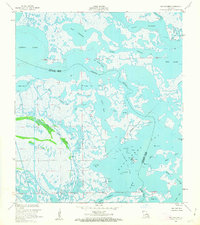
1953 Map of Bay Dosgris
USGS Topo · Published 1963About this map
Grand Bayou winds through the intricate saltwater marshes of the Louisiana coast in this mid-century survey of the boundary between Lafourche and Jefferson Parishes. This era of the landscape is defined by the burgeoning offshore and coastal energy industry, anchored here by the Bay De Chene Oil Field. The map records an environment of fluid borders where water and land are often indistinguishable, featuring complex systems like the East Fork Bayou l'Ours and the broad waters of Bay Dosgris. Strategic infrastructure for the period is visible through numerous Oil Wells, a prominent Radio Tower, and several Submerged Pipelines that crisscross the bays. These features illustrate the industrialization of the wetlands before significant coastal erosion altered the footprints of places like Hackberry Bay and Mud Lake.
Find a feature on this map
27 named features on this map. Tap any name to fly to it.
Don’t see what you’re looking for? This feature index may not catch every label — zoom into the map to look around manually.
Map Details
Editions of this 1953 Bay Dosgris Map
3 editions found
Other maps of this area

1891 · Pointe a La Hache
USGS Topo · 1:62,500

1892 · Barataria
USGS Topo · 1:62,500

1892 · Creole
USGS Topo · 1:62,500

1892 · Pointe a La Hache
USGS Topo · 1:62,500

1893 · Fort Livingston
USGS Topo · 1:62,500

1935 · Mink Bayou
USGS Topo · 1:31,680

1935 · Wilkinson Bay
USGS Topo · 1:31,680

1939 · Pointe a La Hache
USGS Topo · 1:62,500

1941 · Barataria
USGS Topo · 1:62,500

1944 · Barataria
USGS Topo · 1:62,500