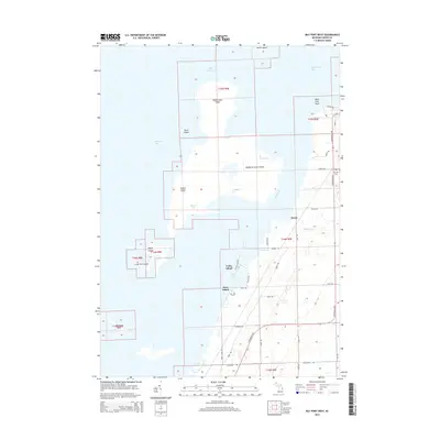
2014 Map of Bay Port West
USGS Topo · Published 2014About this map
The eastern shores of Saginaw Bay meet the sprawling archipelago of Wild Fowl Bay in this 2014 survey. The landscape is defined by its complex shoreline, where dredging and natural processes have created distinct water passages like Rush Cut, Dynamite Cut, and Boxcar Cut. These channels thread between a series of named landforms including Middle Grounds Island, Maisou Island, and Heisterman Island, reflecting a shoreline shaped as much by maritime utility as by the elements.
Find a feature on this map
47 named features on this map. Tap any name to fly to it.
Don’t see what you’re looking for? This feature index may not catch every label — zoom into the map to look around manually.
Map Details
Editions of this 2014 Bay Port West Map
This is the sole edition of this map. No revisions or reprints were ever made.
Other maps of this area

1954 · Flint
USGS Topo · 1:250,000

1958 · Flint
USGS Topo · 1:250,000

1963 · Fish Point
USGS Topo · 1:24,000

1963 · Owendale
USGS Topo · 1:24,000

1963 · Sebewaing
USGS Topo · 1:24,000

1970 · Bay Port West
USGS Topo · 1:24,000

1970 · Bay Port East
USGS Topo · 1:24,000

1970 · Caseville
USGS Topo · 1:24,000

1970 · Sand Point
USGS Topo · 1:24,000
1984 · Bay City
USGS Topo · 1:100,000