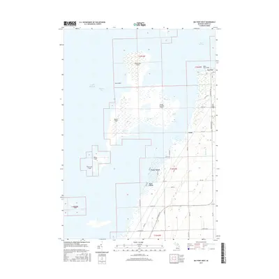
2017 Map of Bay Port West
USGS Topo · Published 2017About this map
Saginaw Bay and the islands of Wild Fowl Bay dominate this coastal survey of Huron County's western shore. The settlement of Bay Port anchors the shoreline at Wild Fowl Point, where dredging projects like Rush Cut and Dynamite Cut illustrate the modification of the shallow waters between Heisterman Island and the mainland. This environment is characterized by a complex network of marshy islands including Maisou Island, Middle Grounds Island, and Defoe Island, which shift into the agricultural flats of Fairhaven Township. Inland from the Lake Huron coast, the landscape is defined by a rigid grid of rural roads such as Kilmanagh Rd and N Unionville Rd, serving the small community at Weale and the waterfront enclave of Rose Island. The map also identifies the Bay Port Cem and several small water features like Shebeon Cr and Blind Pass.
Find a feature on this map
47 named features on this map. Tap any name to fly to it.
Don’t see what you’re looking for? This feature index may not catch every label — zoom into the map to look around manually.
Map Details
Editions of this 2017 Bay Port West Map
This is the sole edition of this map. No revisions or reprints were ever made.
Other maps of this area

1954 · Flint
USGS Topo · 1:250,000

1958 · Flint
USGS Topo · 1:250,000

1963 · Fish Point
USGS Topo · 1:24,000

1963 · Owendale
USGS Topo · 1:24,000

1963 · Sebewaing
USGS Topo · 1:24,000

1970 · Bay Port West
USGS Topo · 1:24,000

1970 · Bay Port East
USGS Topo · 1:24,000

1970 · Caseville
USGS Topo · 1:24,000

1970 · Sand Point
USGS Topo · 1:24,000
1984 · Bay City
USGS Topo · 1:100,000