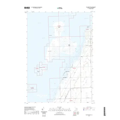
2019 Map of Bay Port West
USGS Topo · Published 2019About this map
Heisterman Island and the complex archipelago of Saginaw Bay dominate this coastal survey of Huron County's western shore. The landscape is defined by the shifting boundaries of water and marsh, where man-made passages like Dynamite Cut, Rush Cut, and Boxcar Cut navigate the Middle Grounds. Along the mainland, the settlement of Bay Port serves as a focal point near the Bay Port Cem, while the smaller community of Weale sits further south along S Unionville Rd. The intricate shoreline is marked by distinctive features such as Wild Fowl Point and the isolated Lone Tree Island. This area reflects a long-standing relationship between the community and the bay, with a road network including Rose Island Rd and Kilmanagh Rd providing access to the seasonal camps and waterfront landings that characterize this stretch of Lake Huron.
Find a feature on this map
49 named features on this map. Tap any name to fly to it.
Don’t see what you’re looking for? This feature index may not catch every label — zoom into the map to look around manually.
Map Details
Editions of this 2019 Bay Port West Map
This is the sole edition of this map. No revisions or reprints were ever made.
Other maps of this area

1954 · Flint
USGS Topo · 1:250,000

1958 · Flint
USGS Topo · 1:250,000

1963 · Fish Point
USGS Topo · 1:24,000

1963 · Owendale
USGS Topo · 1:24,000

1963 · Sebewaing
USGS Topo · 1:24,000

1970 · Bay Port West
USGS Topo · 1:24,000

1970 · Bay Port East
USGS Topo · 1:24,000

1970 · Caseville
USGS Topo · 1:24,000

1970 · Sand Point
USGS Topo · 1:24,000
1984 · Bay City
USGS Topo · 1:100,000