
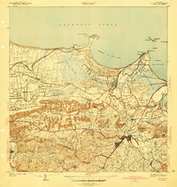
1941 Map of Bayamon
USGS Topo · Published 1941About this map
Central Juanita and the surrounding sugar economy dominate this pre-war coastal landscape, where the American Railroad and its industrial spurs connect the inland hills to the Atlantic shore. The town of Bayamon serves as a hub of activity, featuring the Estacion Bayamon and the large Hospital de Distrito de Bayamon. To the north, the coastline is defined by the Ensenada de Boca Vieja and the fishing village of Palo Seco, while the western edge is bounded by the winding Rio de la Plata. Numerous agricultural settlements like Sabana Seca and Colonia Campanilla are dispersed throughout the terrain, linked by the Linea Ferrea and local roads. The map captures an era of plantation agriculture and early institutional development before the rapid urban expansion of the late 20th century, visible in the cluster of churches such as Iglesia Evangelica and the layout of the Terrenos Publicos near the coast.
Find a feature on this map
81 named features on this map. Tap any name to fly to it.
Don’t see what you’re looking for? This feature index may not catch every label — zoom into the map to look around manually.
Map Details
Editions of this 1941 Bayamon Map
2 editions found
Other maps of this area

1940 · Vega Alta
USGS Topo · 1:30,000

1941 · San Juan
USGS Topo · 1:30,000

1946 · Aguas Buenas
USGS Topo · 1:30,000

1946 · Corozal
USGS Topo · 1:30,000

1946 · Vega Alta
USGS Topo · 1:30,000

1946 · Naranjito
USGS Topo · 1:30,000
1947 · Corozal NE
USGS Topo · 1:10,000

1947 · Aguas Buenas NO
USGS Topo · 1:10,000

1947 · Bayamon
USGS Topo · 1:30,000
1947 · Naranjito NO
USGS Topo · 1:10,000