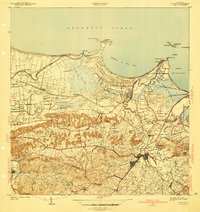
1941 Map of Bayamon
USGS Topo · Published 1941About this map
Bayamon and the surrounding coastal lowlands are captured here in a transition from agricultural estates to a burgeoning urban center just before the mid-century. The landscape is defined by the Rio Bayamon and its numerous tributaries, including Quebrada Catalina, which wind through a mosaic of sugar plantations and early residential developments. The industrial importance of the region is evident in the Central Juanita sugar mill and the Estacion Bayamon, which served as a vital node on the American railroad line. Along the coast, the defensive and maritime geography is highlighted by features like Isla de Cabras and Pta Salinas. Inland, smaller settlements such as Sabana Seca and Vista Alegre dot the terrain, while institutions like the Hospital de Distrito de Bayamon indicate the town's growing role as a regional hub for health and administration in the pre-war era.
Find a feature on this map
81 named features on this map. Tap any name to fly to it.
Don’t see what you’re looking for? This feature index may not catch every label — zoom into the map to look around manually.
Map Details
Editions of this 1941 Bayamon Map
2 editions found
Other maps of this area

1940 · Vega Alta
USGS Topo · 1:30,000

1941 · Bayamon
USGS Topo · 1:30,000

1941 · San Juan
USGS Topo · 1:30,000

1946 · Aguas Buenas
USGS Topo · 1:30,000

1946 · Corozal
USGS Topo · 1:30,000

1946 · Vega Alta
USGS Topo · 1:30,000

1946 · Naranjito
USGS Topo · 1:30,000
1947 · Corozal NE
USGS Topo · 1:10,000

1947 · Aguas Buenas NO
USGS Topo · 1:10,000

1947 · Bayamon
USGS Topo · 1:30,000