
1939 Map of Bayouville
USGS Topo · Published 1942About this map
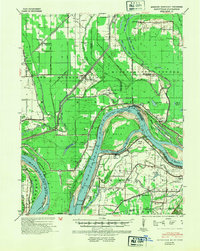
The Mississippi River creates a massive, looping bend around Island No 8, a central feature of this pre-war survey of the borderlands between Missouri, Kentucky, and Tennessee. This riverine landscape is defined by its complex drainage and levee systems, where St Johns Bayou and Black Bayou wind through a patchwork of timber and cleared farmland. The map reveals a rural society built on higher ground, with small settlements like Bayouville and Farrenburg connected by the St Louis Southwestern RR. Genealogy researchers will find significant value in the distribution of family-named landmarks and essential community nodes, including Pinhook Ch & Sch, Walnut Grove Sch, and the Barker Cem. The map illustrates the intensive effort to manage the alluvial valley, featuring numerous surveying tracts like Survey 3187 and engineering works such as the Flood Gate near the Missouri riverbank.
Find a feature on this map
62 named features on this map. Tap any name to fly to it.
Don’t see what you’re looking for? This feature index may not catch every label — zoom into the map to look around manually.
Map Details
Editions of this 1939 Bayouville Map
2 editions found
Other maps of this area

1925 · Reelfoot Lake
USGS Topo · 1:62,500

1931 · Sikeston
USGS Topo · 1:62,500

1934 · Sikeston
USGS Topo · 1:62,500

1939 · Wickliffe
USGS Topo · 1:62,500

1939 · Sikeston
USGS Topo · 1:62,500

1939 · Reelfoot Lake
USGS Topo · 1:62,500

1939 · Charleston
USGS Topo · 1:62,500

1939 · Portageville
USGS Topo · 1:62,500

1939 · Hickman
USGS Topo · 1:62,500

1939 · New Madrid
USGS Topo · 1:62,500