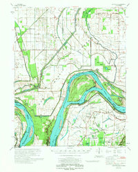
1972 Map of Bayouville
USGS Topo · Published 1972About this map
Ancient earthworks and complex river geography converge where the Mississippi River creates the sharp Bend of Island No 8. This 1972 survey records a landscape shaped by both prehistoric habitation and modern flood control, featuring the Corner Stone Indian Mound and Henderson Mound alongside an intricate network of drainage ditches like the Southwestern Ditch. The map details the tri-state intersection of Missouri, Kentucky, and Tennessee, capturing small riverfront communities such as Dorena and Bayouville.
Find a feature on this map
53 named features on this map. Tap any name to fly to it.
Don’t see what you’re looking for? This feature index may not catch every label — zoom into the map to look around manually.
Map Details
Editions of this 1972 Bayouville Map
This is the sole edition of this map. No revisions or reprints were ever made.
Other maps of this area

1925 · Reelfoot Lake
USGS Topo · 1:62,500

1931 · Sikeston
USGS Topo · 1:62,500

1934 · Sikeston
USGS Topo · 1:62,500

1939 · Wickliffe
USGS Topo · 1:62,500

1939 · Sikeston
USGS Topo · 1:62,500

1939 · Reelfoot Lake
USGS Topo · 1:62,500

1939 · Charleston
USGS Topo · 1:62,500

1939 · Portageville
USGS Topo · 1:62,500

1939 · Hickman
USGS Topo · 1:62,500

1939 · New Madrid
USGS Topo · 1:62,500