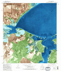
1979 Map of Bayside
USGS Topo · Published 1995About this map
Bayside sits prominently on the shoreline of Copano Bay, serving as a coastal hub where the land meets a complex network of reefs and inlets in the late 1970s. The landscape is defined by its industrial and agricultural balance, with numerous oil wells and tanks scattered across the South Copano Bay Oil Field and surrounding inland areas. The geography of the coast is particularly intricate, featuring the Forty Acre Reef and Shellbank Reef submerged in the bay, while the Aransas River flows into the marshy expanse of Egery Flats. Further south, the map reveals a transition toward more managed landscapes, including the Live Oak Country Club and the structured Tailings Ponds. Large tracts of land are partitioned along Lee Miller Road, illustrating the intersection of residential, energy-sector, and natural water features like Swan Lake and Fresh Water Lake.
Find a feature on this map
29 named features on this map. Tap any name to fly to it.
Don’t see what you’re looking for? This feature index may not catch every label — zoom into the map to look around manually.
Map Details
Editions of this 1979 Bayside Map
This is the sole edition of this map. No revisions or reprints were ever made.
Other maps of this area

1925 · Aransas Pass
USGS Topo · 1:62,500

1925 · Corpus Christi
USGS Topo · 1:62,500

1950 · Corpus Christi
USGS Topo · 1:250,000

1951 · Corpus Christi
USGS Topo · 1:62,500

1953 · Beeville
USGS Topo · 1:250,000

1954 · Rockport
USGS Topo · 1:62,500

1954 · Aransas Pass
USGS Topo · 1:24,000

1954 · Woodsboro
USGS Topo · 1:62,500

1954 · Estes
USGS Topo · 1:24,000

1954 · Aransas Pass
USGS Topo · 1:62,500
Featured Places
- Bayside, TX
- Bayview Estates Colonia, TX
- Old Saint Marys, Bayside
- San Patricio County, TX
- Aransas County, TX