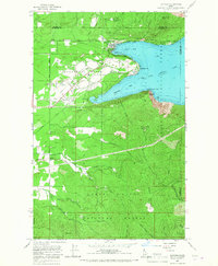
1967 Map of Bayview
USGS Topo · Published 1967About this map
Bayview serves as a primary gateway to the southern reaches of Pend Oreille Lake in the late 1960s, where the landscape transitions from industrial and military use to public recreation. Much of the shoreline is defined by the Naval Reservation, which includes a Naval Laboratory and Sewage Disposal facilities near Blackwell Point. Adjacent to these naval operations, the extensive grounds of Farragut State Park occupy the former site of a massive World War II naval training station, retaining features like a Rifle Range and an Amphitheater.
Find a feature on this map
54 named features on this map. Tap any name to fly to it.
Don’t see what you’re looking for? This feature index may not catch every label — zoom into the map to look around manually.
Map Details
Editions of this 1967 Bayview Map
3 editions found
Other maps of this area

1901 · Sandpoint
USGS Topo · 1:125,000

1903 · Rathdrum
USGS Topo · 1:125,000

1909 · Cataldo
USGS Topo · 1:125,000

1911 · Cataldo
USGS Topo · 1:125,000

1911 · Priest Lake
USGS Topo · 1:250,000

1911 · Sandpoint
USGS Topo · 1:125,000

1913 · Priest Lake
USGS Topo · 1:250,000

1949 · Packsaddle Mtn
USGS Topo · 1:62,500

1951 · Packsaddle Mtn
USGS Topo · 1:62,500

1955 · Spokane
USGS Topo · 1:250,000