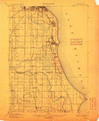
1901 Map of Bayview
USGS Topo · Published 1910About this map
Lake Michigan forms the eastern edge of this early twentieth-century survey, where the industrial and residential expansion of the Milwaukee area meets the rural farmlands of northern Racine County. The shoreline is defined by the burgeoning municipalities of Cudahy and South Milwaukee, established along the busy corridors of the Chicago and North Western Railroad and the Chicago Milwaukee and Electric Railroad. Inland, the landscape transitions into a grid of small settlements and post offices, such as New Coeln, Paynesville, and Lamberton P.O., which served as local hubs before widespread suburbanization.
Find a feature on this map
42 named features on this map. Tap any name to fly to it.
Don’t see what you’re looking for? This feature index may not catch every label — zoom into the map to look around manually.
Map Details
Editions of this 1901 Bayview Map
4 editions found
Other maps of this area

1891 · Bayview
USGS Topo · 1:62,500

1891 · Muskego
USGS Topo · 1:62,500

1892 · Milwaukee
USGS Topo · 1:62,500

1892 · Waukesha
USGS Topo · 1:62,500

1892 · Racine
USGS Topo · 1:62,500

1893 · Silver Lake
USGS Topo · 1:62,500

1901 · Milwaukee
USGS Topo · 1:62,500

1901 · Waukesha
USGS Topo · 1:62,500

1901 · Bayview
USGS Topo · 1:62,500

1901 · Muskego
USGS Topo · 1:62,500