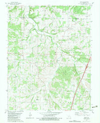
1982 Map of Beach
USGS Topo · Published 1983About this map
The Niangua River and its multiple forks carve through the landscape of the Washington and Jackson townships in this early 1980s topographical record. Rural communities like Beach and Forkners Hill serve as local anchors in a region defined by its timber and river valleys. The confluence of the West Fork Niangua River and East Fork Niangua River occurs amidst protected lands, including the Niangua State Forest and Goose Creek State Forest, highlighting the conservation of the Ozark hillsides.
Find a feature on this map
43 named features on this map. Tap any name to fly to it.
Don’t see what you’re looking for? This feature index may not catch every label — zoom into the map to look around manually.
Map Details
Editions of this 1982 Beach Map
This is the sole edition of this map. No revisions or reprints were ever made.
Other maps of this area

1884 · Springfield
USGS Topo · 1:125,000

1884 · Bolivar
USGS Topo · 1:125,000

1886 · Springfield
USGS Topo · 1:125,000

1892 · Bolivar
USGS Topo · 1:125,000

1939 · Long Lane
USGS Topo · 1:62,500

1942 · Long Lane
USGS Topo · 1:62,500

1946 · Niangua
USGS Topo · 1:62,500

1947 · Strafford
USGS Topo · 1:62,500

1948 · Niangua
USGS Topo · 1:62,500

1948 · Strafford
USGS Topo · 1:62,500