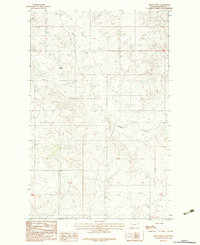
1983 Map of Beam School
USGS Topo · Published 1983About this map
Beam School stands as a lonely landmark within the Fort Peck Indian Reservation in Roosevelt County, marking a site of community and education in this high plains landscape. The terrain is defined by the winding course of Smoke Creek, which carves through the undulating topography as it flows toward the southeast. This 1983 provisional survey captures the area as it appeared during the late twentieth century, showing a network of unimproved roads and trails that connect isolated farmsteads and grain bins across the prairie. The vast, open character of the land is further punctuated by features like Dry Lake and scattered gravel pits, reflecting a rural economy centered on dryland ranching and resource extraction. The map also delineates the precise township and range boundaries of the region, including t32n t31n and t31n t30n, which are essential for property research and genealogical study in this part of Montana.
Find a feature on this map
6 named features on this map. Tap any name to fly to it.
Don’t see what you’re looking for? This feature index may not catch every label — zoom into the map to look around manually.
Map Details
Editions of this 1983 Beam School Map
This is the sole edition of this map. No revisions or reprints were ever made.
Other maps of this area

1909 · Smoke Creek
USGS Topo · 1:62,500

1912 · Hay Creek
USGS Topo · 1:62,500

1912 · Smoke Creek
USGS Topo · 1:62,500

1950 · Coyote Coulee
USGS Topo · 1:24,000

1954 · Wolf Point
USGS Topo · 1:250,000

1958 · Wolf Point
USGS Topo · 1:250,000

1973 · Pleasant Prairie
USGS Topo · 1:24,000

1982 · Culbertson
USGS Topo · 1:100,000
1983 · Smoke Creek SW
USGS Topo · 1:24,000
1983 · Geddart Lake
USGS Topo · 1:24,000