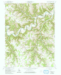
1959 Map of Bear Branch
USGS Topo · Published 1993About this map
Laughery Creek carves a deep, serpentine path through southeastern Indiana, defining the boundary between several townships including Caesar Creek and Pike. This survey, reflecting the landscape in the late 1950s, documents a rural agricultural region where small settlements like Farmers Retreat and Milton serve as local anchors. The map reveals a tight-knit community structure, often organized around spiritual and educational centers such as St Johns Ch, Olive Branch Ch, and the Freedom Sch.
Find a feature on this map
54 named features on this map. Tap any name to fly to it.
Don’t see what you’re looking for? This feature index may not catch every label — zoom into the map to look around manually.
Map Details
Editions of this 1959 Bear Branch Map
Other maps of this area

1915 · Lawrenceburg
USGS Topo · 1:48,000

1928 · Lawrenceburg
USGS Topo · 1:62,500

1932 · Lawrenceburg
USGS Topo · 1:62,500

1943 · Florence
USGS Topo · 1:24,000

1943 · Aberdeen
USGS Topo · 1:24,000

1943 · Aurora
USGS Topo · 1:24,000

1943 · Vevay North
USGS Topo · 1:24,000

1946 · Milan
USGS Topo · 1:24,000

1951 · Florence
USGS Topo · 1:24,000

1953 · Aberdeen
USGS Topo · 1:24,000